cybersecurity
wireless
threat-detection
NetPlot
NetPlot is a standalone Windows app for viewing converted WiGLE CSV exports on an interactive map.
February 2026
published
About This Project
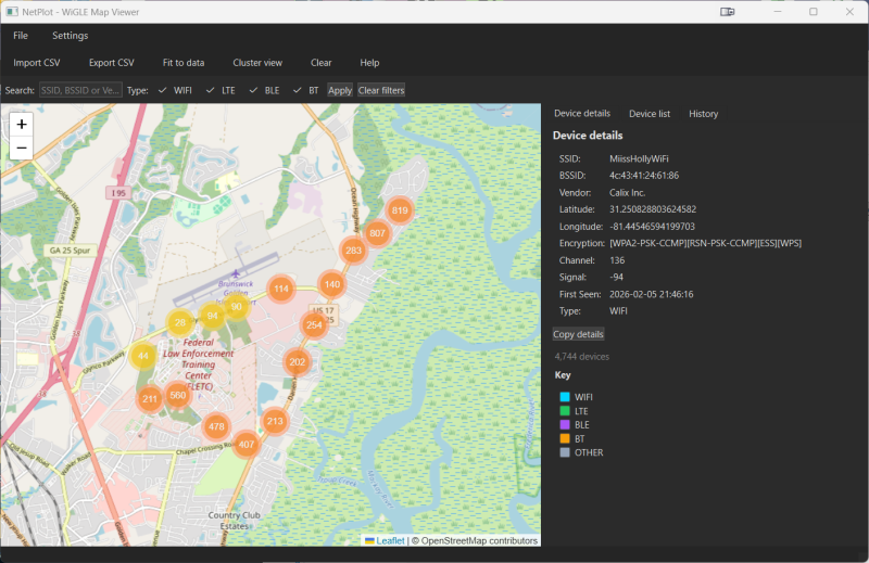
NetPlot is a standalone Windows app for viewing converted WiGLE CSV exports on an interactive map. Convert your WiGLE CSV export using the WiGLE CSV Converter, then import your wardriving data, filter by SSID/BSSID/vendor or device type, and explore devices on a Leaflet map with clustering and click-to-detail.
No server required—the map loads from local files; tiles (e.g. OpenStreetMap) load from the internet when available.
No server required—the map loads from local files; tiles (e.g. OpenStreetMap) load from the internet when available.
Key Features
Import converted WiGLE CSV — Load WiGLE-style exports (latitude/longitude and common column names supported).
Interactive map — Leaflet map with marker clustering, fit-to-data, and click-to-select.
Device list & details — Table of devices in the current view; click a row to zoom and show details (SSID, BSSID, vendor, encryption, channel, signal, etc.).
Filtering — Search by SSID, BSSID, or vendor; filter by type (WIFI, LTE, BLE, BT).
Export — Export the current (filtered) view or in-view devices to CSV.
Portable build — Build a single folder (NetPlot.exe + _internal) and copy it to a thumb drive or another PC; no install needed.
Project Information
Duration
1 week
Team Size
1
Status
Published
Technologies Used
Python
Platforms
Windows
Downloads
Download File
NetPlot.7z
191.65 MB